
It’s amazing to me, still, in spite of that last quarter mile. It’s one of those things that catches people’s attention, even though they might not try it themselves. It could be the act itself or the timing. Regardless, I’m still in awe. It was our vacation Day #3, the reason for this trip, and it was FABULOUS.
We hike in Oregon on a regular basis, and over the past few years, we’ve seen several old fire towers; in fact, The Husband likes to choose our hikes based on whether there’s a tower up top. Returning to a certain spot in Montana had long been on his bucket list but I didn’t hear about it until more recently. At first I thought, “What are the chances?” He learned last year that someone there organizes hikes of this very area, including Mt. Henry. By the time he found out, it was too late to plan a trip.
Well. He’s never been one to give up.
While in college The Husband was the lookout in a fire tower one summer–about seven miles from the Canadian border–for three weeks. It was a summer job with the Forest Service for which he came all the way from Pennsylvania. The destination: Mt. Henry, Montana (P.O. Box: In The Sticks). Nearest town area: Yaak.

Montana bound
The eye wear takes us back a bit as does the car, but that’s another post. Answering a Penn State ad, these adventuresome college boys headed west. They were 20 years old and the year was 1968.
This year’s vacation location turned out to be Montana. We were going to see The Husband’s fire tower atop Mt. Henry. Wondering where Yaak is located, I checked a few maps and see it is quite close to the Canadian border. Do you see Yaak in the center near the top?
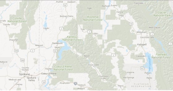 Here’s a closer view below. The top red X is Yaak, the bottom red X is Sylvanite. The Ranger Station back then–where he lived when not in the tower, when he worked on the roads–was located in Sylvanite. The arrow points to Mt. Henry. The horizontal line near the top is the border, and the area is in the Kootenai National Forest.

We looked for the Ranger Station in Sylvanite and found a few remnants:


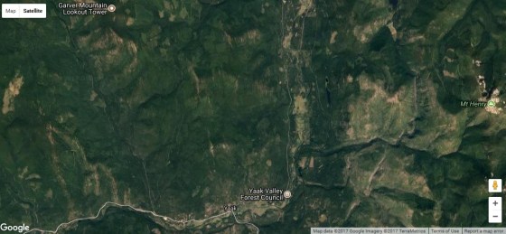
And, finally, Mt. Henry is on the right of this map and Yaak at the bottom.
 The reason for this trip: to see the fire tower where The Husband worked in 1968. The hike: eight and a half miles.
July 29, 2017; the day was finally here. We rose early and had breakfast at The Dirty Shame Saloon. You read that correctly (and, while the Yaak dining choices are few, it didn’t disappoint. Click the link to see Chef Floyd’s plate-sized huckleberry pancakes).
After breakfast, we met in front of the Yaak, Mercantile (across the street from The Dirty Shame) at 9:00 a.m.–we were Mel, Edwin, Jessie, Amy, Heidi, The Husband, and myself. Oh, and Juan, Heidi’s dog–to caravan to the trail head. After meeting everyone, I had a really good feeling about this hike. I felt energized. I was very glad we decided to go.
 I used to backpack and hike and run for exercise. Crabby knees and achy feet now slow me down, but I refuse to sit home and watch life pass me by. With brand new custom inserts, I was ready.
And, nervous. When The Husband was here in 1968, he came across a mama bear and her three cubs ON THIS VERY TRAIL. I’d heard this story many times, and, while he knew to back away and did so without incident, it can go horribly wrong. We reviewed bear safety before the hike, but I was still nervous.
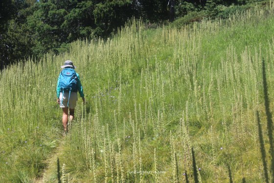
It was with trepidation that I hit the trail, but to my delight, no more than 10 minutes in, I realized something that blew my fears out of the water. We were seven and a half (there is safety in numbers), we were chatty (bears don’t like noise), and three of us had bear spray (no guarantee but I felt a helluva lot better having it). Once I relaxed about our furry neighbors, I was able to enjoy this beautiful hike. I could sense I was with a fabulous group of people and I wanted to get to know them. I hung on to that good feeling. And, oh, what a beautiful area.
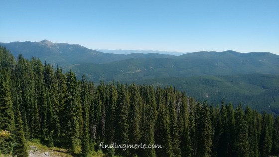
part way up, the hillside opened to this view
lots of bear grass not in bloom

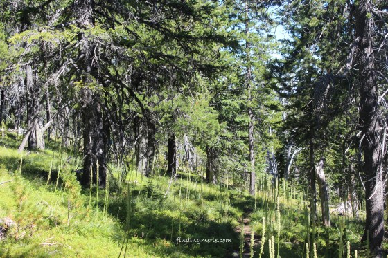
making our way

lavender cheer along the trail
Several rests were much appreciated.

Amy and Edwin
Amy in the bear grass
Part way up we found the most delightful lake.
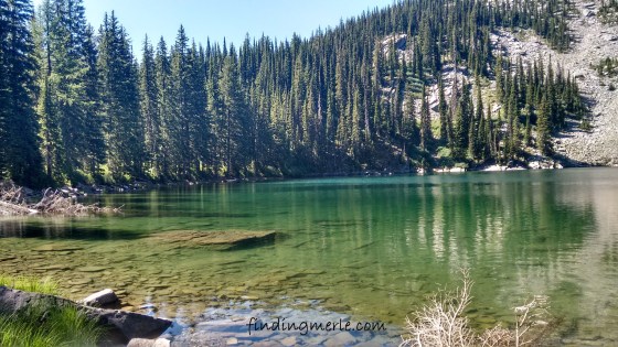
Mt Henry lake

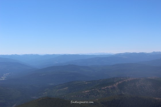
the top of that ridge is where we were headed
Here is that same ridge 49 years earlier, and a view of the lake from the ridge top.


As we hiked along I was quite impressed by the passion I heard from my hiking companions. Passion for the environment, that is. Several of them, maybe most, are part of a group, work for a group, or volunteer with a group whose aim is to protect and preserve the Montana wilderness. I happily hiked along, kept an eye out for bears, but smiled as we ascended, impressed by their passion, knowing this land is in good hands.
 Before I realized it we were near the top. I knew the last quarter mile would be steep, but didn’t know the hike was rated “difficult.” I so appreciate the team effort in the group to stay together. These people are caring hikers and I smile now to think of their good hearts.
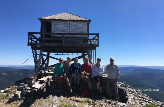
We hike on a regular basis. I have done “difficult” hikes. The final ascent was a challenge, but once I found a tree and dehydrated myself, and once we began to see portions of the tower–THE REASON FOR THIS TRIP–I could not contain my excitement. I paced myself and kept moving. I would see that tower, I would go inside, I would see the look on The Husband’s face, 49 years later.

and, there it is

The Husband at Mt. Henry lookout tower, 2017
It was impressively breathtaking and worth every single step, now and then:


The door was “secured” with a loose board, so, we took advantage:
A bit windy up top, Jessie had to spot Mel so Mel could get the next photos of Bruce and I up top:


And, while up top, I spied Edwin enjoying the view:
 Here is the tower in 2017 and in 1968:


He did it; he made his way back 49 years later. He accomplished something he’d been wanting to do for a long time. It was a fabulous day on many levels. While up top, we lounged on the rocks for lunch, took a rest, and wandered to absorb the view. I took off my socks and boots, just because. And, of course, photos of each other:


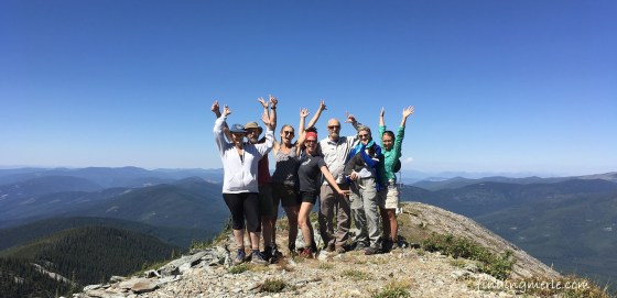
And the best part: GROUP SHOTS!!!

Karen, Bruce, Jessie, Heidi, Edwin, Mel holding Juan, Amy
 While it was very tempting to stay, all good things must end. Besides, we knew we had something very appealing awaiting us down trail.
The trek down was just as lovely.

Karen, Heidi, and Juan
 We each were ready for the cooling freshness of that beautiful lake; some swam, some dipped.


 Shortly after, we reached the trail head once again, and, along with tired feet, I believe collectively refreshed and happy to have visited a gorgeous area and to have found new friends in these wonderful hikers. It was a dream come true for one and a beautiful hike for the rest. My cup is full.

Mt. Henry, 2017
Thank you all, new friends, for a fabulous day.
Photo courtesy: Heidi J., who graciously shared her photos of the day. Heidi took the group shots at the top. Thank you, Heidi! ❤
Hike: Organized by Jessie. Thank you, Jessie. ❤

Looks like a fabulous trip and fab photos! Hope you’re Karen? xx
LikeLiked by 1 person
Hey, there. I’m OK, was pretty sick a couple weeks ago. I had a reaction to all the smoke in the air from these fires, but I’m on the mend. The Eagle Creek fire in Oregon jumped the Columbia River due to strong winds. Now it’s on the Washington side. Heart breaking. This is our beautiful playground and a great tourist area. Hope the rains coming this weekend zap this thing. Been working on genealogy quite a bit. How are you doing?
LikeLike
What a splendid day and wonderful gift for your husband! I so enjoyed this post with the photographs, personal history, and your reactions as you hiked. Very nice.
LikeLiked by 1 person
Thank you, Janet. It was a great day and we have talked of going back to that area; maybe not that same hike, but to explore the area in general. It is beautiful. Thanks for stopping by. Have a great week!
LikeLike
I am just stunned by the beauty. It’s hard to believe there are still so many unsettled, uncluttered places in this amazing country of ours. And kudos to you and the group for making it to the top!
LikeLiked by 1 person
Me, too. It was simply breathtaking. But, I’ll also say I’m not sure I’d want to be caught alone on any of those isolated roads at night…for several reasons. By day, lovely. 🙂
LikeLiked by 1 person
What an accomplishment! And the views were worth both the wait and the effort!
LikeLiked by 1 person
Thank you, Ann. It sure felt great to reach the top. It was warm/windy up top…perfect. 🙂
LikeLike